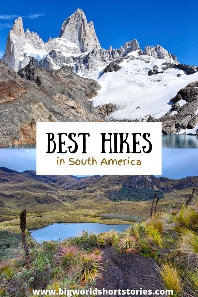
13 Best Hikes in South America
South America boasts the majestic Andean Mountain Range, hosting some of the world’s highest peaks. It’s no surprise that some of the hiking trails In South America like those in Patagonia or the Inca Trail are consistently ranked as the most beautiful hikes in the world. In this blog post, you will find a curated list of the most beautiful hikes in South America, recommended by seasoned travelers and hikers across the globe. Whether you prefer short one-day hikes or extended multi-day treks, you’ll discover the finest trails to fuel your inspiration to conquer yet another summit.
Best Day-Hikes in South America
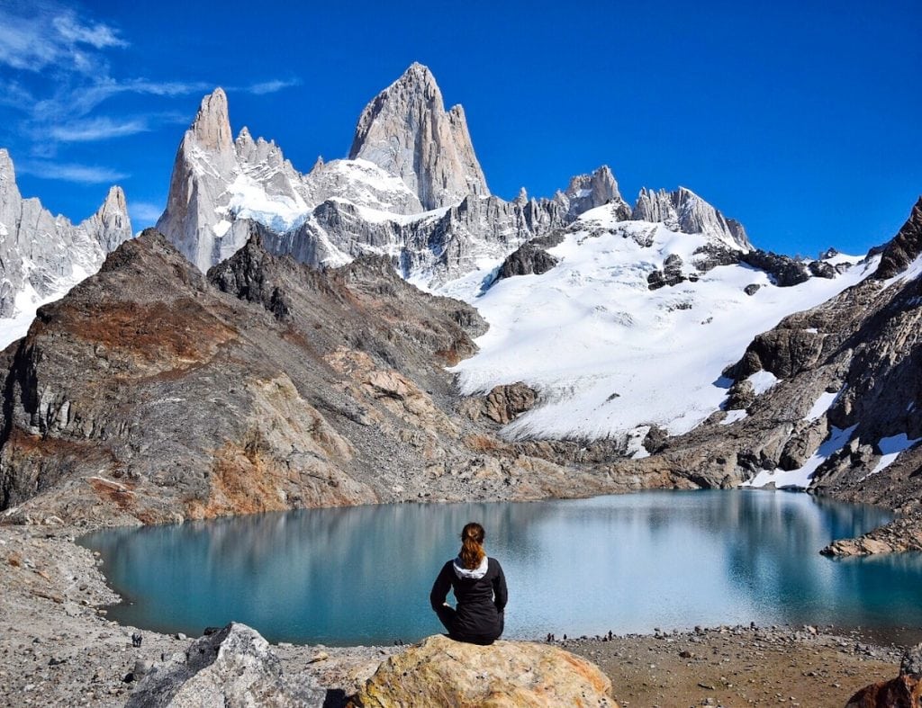
Laguna de los Tres Fitz Roy (Patagonia, Argentina)
Starting Point: El Chalten, Patagonia
Highest Point: 864 m (2,835 ft)
Total Length: 24 to 26 km (15 to 16 miles) depending on the starting point
Difficulty: Hard
Duration: 8 to 10 hours
Trek Type: Point to Point or Out and Back, depending on where you start.
Tour Type: self-guided
The Mount Fitz Roy hike, in Argentine Patagonia is the best day hike in South America, and the good news is that it can be done completely independently.
The trailhead is at the end of St. Martin Street in El Chalten. You will find a sign saying “Sendero al Fitz Roy” pointing you to the rail trail.
This out-and-back hike is for the most part fairly easy. However, once you get to the Rio Blanco rest area (after the Campamento Poincenot) the challenge begins, as suggested by a sign that suggests to anybody who is not truly fit not to continue on the hike. From then on, the trail goes up for one km (0.6 miles) gaining 400 meters (1312 feet). You will be walking up large rock steps and over boulders.
The hike is incredibly rewarding – once you reach the Laguna de los Tres you will have unobstructed views of Mount Fitz Roy. The only toilets along this trail are pit toilets at the Rio Blanco rest area and some bush toilets closer to the river. You will need to carry all the food and water you may need for the day too.
Recommended by Claudia from My Adventures Across The World
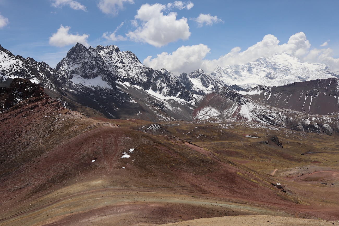
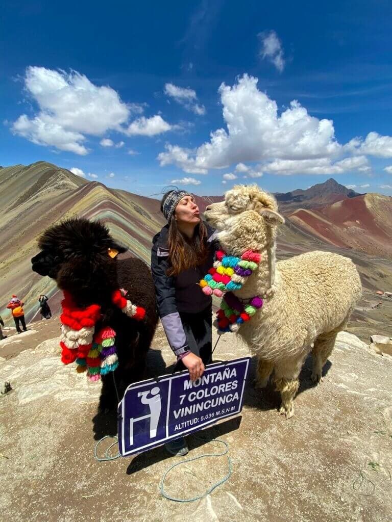
Rainbow Mountain (Peru)
Starting Point: 2,5-hour drive from Cusco
Highest Point: 5200 m (17060 ft)
Total Length: 8 km (5 miles)
Difficulty: Hard
Duration: 4 hours
Trek Type: Out-and-back
Tour Type: Self-guided is possible but a tour guide is highly recommended
The Rainbow Mountain which is also known as Vinicunca or Montaña de Siete Colores, has grown in popularity in recent years and is quickly becoming the second most visited attraction in Peru after Machu Picchu. If you are staying several days in Cusco, then you should consider doing the Rainbow Mountain trek.
The Rainbow Mountain hike in Peru is one of the most challenging but rewarding hikes in South America. Although it is only an 8-kilometer (5 miles) day hike, the elevation gain from Cusco (3.400 m/ 11155 ft) to the top of Rainbow Mountain (5,200 m/17,060 ft) gives most people altitude sickness. If you are worried about the Rainbow Mountain hike being too challenging, you can rent a horse to take you up (and down) the mountain directly at the trailhead.
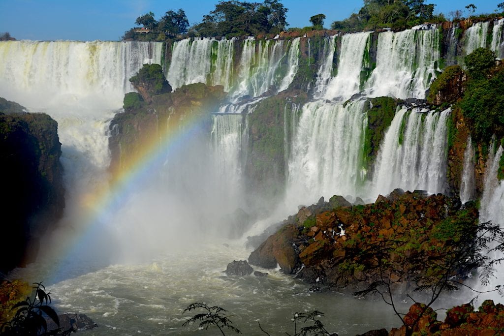
Iguazu Falls Circuit (Brazil, Argentina)
Starting Point: Iguazu Falls National Park
Highest Point: 185 meters (610 feet)
Total Length: 5 km (3.1 miles)
Difficulty: Easy
Duration: 1-2 hours
Track Type: Loop
Tour Type: Self-guided
Iguazu Falls is a major bucket list destination for many travelers for good reason. It truly lives up to the hype with its incredible network of massive waterfalls. The cascades straddle the border between Brazil and Argentina. The Iguazu Falls Circuit is composed of the lower and upper circuit trails. You only need a few hours to complete both the upper and lower loop of the Argentina circuit, however many people spend at least two days at Iguazu to also visit the Brazilian side. The trail is only about 3 miles and has about 60 meters (200 feet) of elevation gain.
No guide is needed to do the trail. It is very well-marked and maintained. There are stairs and ramps built into the trail network to accommodate traveler needs. There are bathrooms in the park, as well as concessions and Wi-Fi at the central hubs at the start and end of the trail. To get to the Iguazu Falls Circuit, most people will first need to fly into Puerto Iguazu Airport (Aeropuerto Internacional Cataratas del Iguazú).
Recommended by Taylor from Taytrum Travels
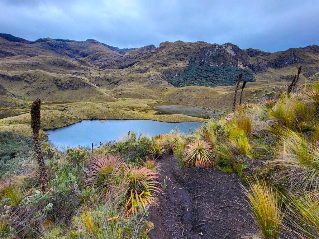
Route 1 at Cajas National Park (Ecuador)
Starting Point: Cuenca
Highest Point: 10,000 ft (3048 m)
Total length: 2.5 miles (4 km)
Difficulty: Moderate
Duration: 3 hours
Trek type: Loop
Tour Type: Self-guided but a professional guide is recommended
Hiking at Cajas National Park is one of the best things to do in Cuenca. It is also one of the best hikes in South America. You can get to Cajas National Park by booking a day trip from Cuenca or catching a public bus from Terminal Terrestre. If you choose to take a public bus, better speak with park staff about where to catch the bus back for your return journey. This part might be a little confusing but you will figure it out once you are there.
Upon arriving at the national park, the main office asks that visitors sign in with an ID. The park staff then will explain park safety and rules. The main office is the only place with restrooms in the national park. There is nowhere to purchase food within the national park, so pack your snacks and lunch in advance.
The closest international airport to Cajas National Park is Mariscal Lamar International Airport. The hike is special because the vibrant greenery paints a stunning backdrop in the Andes Mountain Range. The views are like no other!
Recommended by Alyssa of An Apple a Plane
Best Long-Distance Hikes in South America
Some of the most beautiful hikes in South America are long-distance hikes which take several days to complete. The hikes listed below have mostly moderate difficulty and don’t require any special equipment or climbing skills. Multi-day trekking has many benefits both for your physical and mental health and allows slow travel which is more rewarding and sustainable.
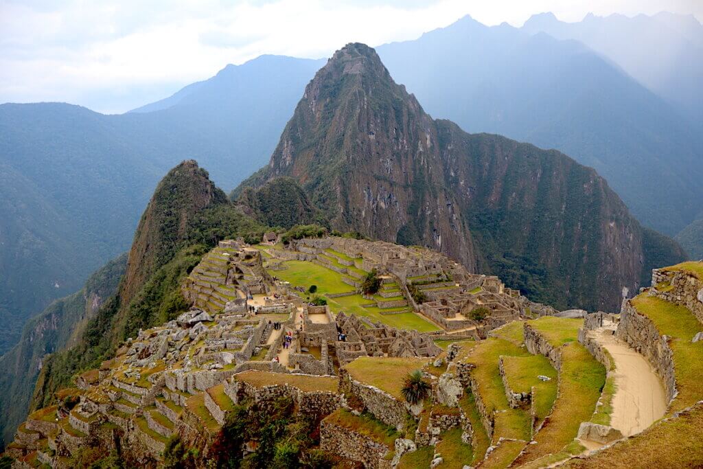
Inca Trail (Peru)
Starting Point: KM 82 between Cusco and Ollantaytambo
Highest Point: 4200 m (13780 ft) Dead Woman’s Pass
Total Length: 26 miles (43km)
Difficulty: Moderate
Duration: 4 days (3 nights)
Trek Type: One way (point to point)
Tour Type: A permit and a tour guide are mandatory
The Inca Trail to Machu Picchu in Peru is by far the most famous hiking trail in South America. It is also consistently ranked as top 5 hikes in the world. Inca Trail is so popular because it is a rare combination of culture and nature. During the hike, you will pass by fascinating Incan ruins hidden in the jungle of the Amazon basin while enjoying snow-capped Andean mountains. At the end of the hike, you have the reward of a once-in-a-lifetime view of Machu Picchu, which sits below as you step through the Sun Gate.
The Classic Inca trail is 26 miles (43km) 4 days 3 nights hike. While the Classic Inca Trail is the most popular hiking trail to Machu Picchu, not everyone is ready to spend 4 days hiking and 3 nights camping in the jungle with mosquitos. The Short Inca Trail is an easier 2-day hike and is ideal for people wanting the experience the best of the Inca Trail without sleeping in tents or spending 4 days hiking. There are bathrooms on the way mostly at the camping sites or checkpoints. There are no restaurants or huts on the way, so you will need to carry enough food and drinks with you.
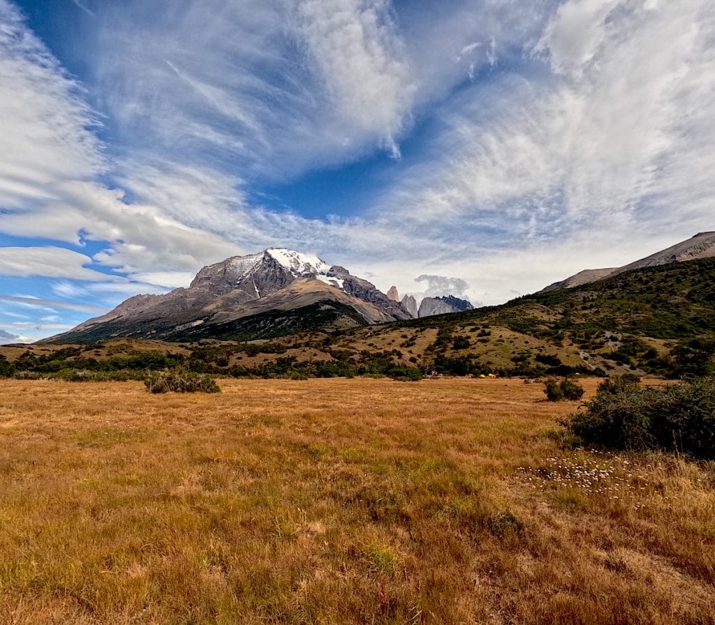
W Trek Patagonia (Chile)
Starting Point: Puerto Natales in Torres Del Paine National Park
Highest Point: 1,100 meters
Total Length: 80 km
Difficulty: Moderate
Duration: 5 days
Trek Type: Point-to-Point
Tour Type: Self-guided
Torres Del Paine National Park is home to the famous W Trek. It’s one of the best multi-day hikes in Patagonia thanks to the impressive landscapes and iconic sights. These include Grey Glacier, Mirador Las Torres, and French Valley. The notorious Patagonia weather is yet another aspect that makes this hike so unique.
Most people choose to do the W Trek independently. The trail is easy to follow and doesn’t involve any technical climbing or high-altitude trekking. Campsites and Refugios are dotted throughout the route and you can buy food and drinks here. Because of the high demand, there is limited availability for accommodation so your W Trek needs to be booked months in advance. Keep in mind that October to April are the best months to hike in Patagonia.
The town of Puerto Natales in Chile is the gateway to Torres Del Paine. It has an airport, but many people choose to do a land crossing over the Argentina-Chilean border instead. From Puerto Natales, you’ll need to take a 90-minute bus to get to the park.
Recommended by Carryn from Torn Tackies Travel
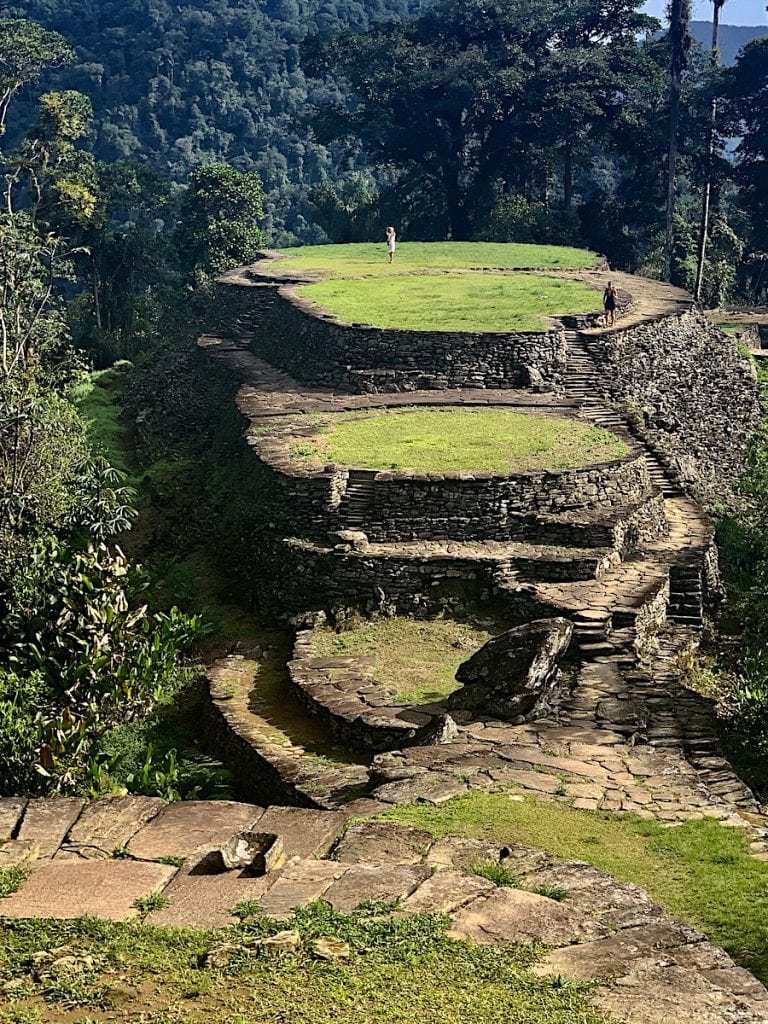
The Lost City Trek (Ciudad Perdida, Colombia)
Starting Point: Machete Pelao
Highest Point: 3900 ft (1200 meters)
Total Length: 50 km
Difficulty: Hard
Duration: 5 days
Trek Type: Roundtrip
Tour Type: A tour guide is mandatory
If you love hiking, a challenge, and a fair share of adventure, you want to put The Colombian Lost City trek, or Ciudad Perdida in Spanish, on your itinerary!
The majestic remnants of the Lost City are nestled deep in the Sierra Nevada mountains in Colombia. You can fly to charming Santa Marta, which is famous for being one of the oldest cities in South America!
This seven-day guided jungle hike (five hiking days) starts from Machete Pelao, two hours from Santa Marta, and is categorized as challenging because of altitude, basic accommodation, heat, and humidity.
Situated at 3900 ft (1200 meters), you will trek through farmland, lush jungles, and various fascinating indigenous communities to reach this hidden oasis. Enjoy amazing views and incredible flora and fauna before you reach this sacred space in the mountains to take in the tranquil ambiance of centuries past.
The most challenging part is the “summit push,” where you conquer the 1200 famous timeworn steps created with natural rocks that will take you to the top!
A guided, all-inclusive tour is mandatory to protect the path and the ancient ruins, and you will appreciate the tour guides for their trekking tips (hydrate!), local knowledge, and incredible insight into the history of this area from ancient times.
Recommended by Hege from The World by Hege
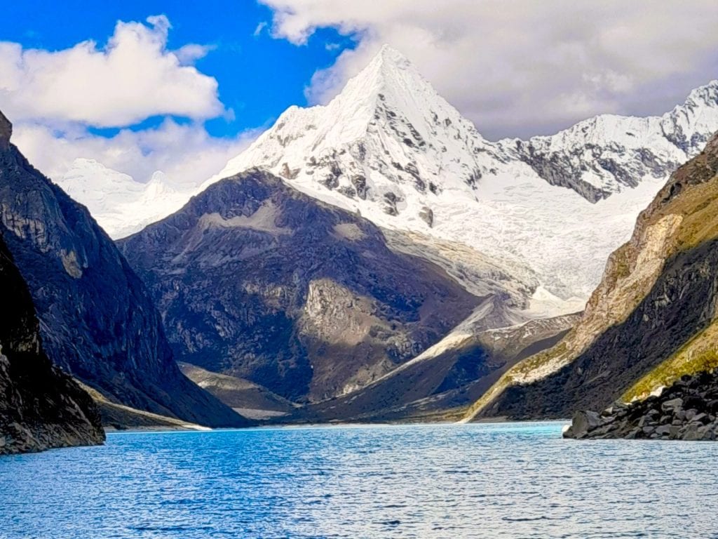
Huahhuash Trek (Huaraz,Peru)
Starting Point: Huaraz
Highest Point: 5,490 m(18,000 ft)
Total Length: 130 km (81 miles)
Difficulty: Hard
Duration: 10 days (9 nights)
Trek Type: One-way (Point-to-Point)
Tour Type: Self-guided but a professional tour guide is highly recommended.
The Huayhuash trek, in Huaraz, Peru, is considered one of the most beautiful in the world. It takes you through stunning landscapes in the Andes, including turquoise lakes and snow-capped mountains. Halfway along the way, you can also enjoy thermal waters for a well-deserved treat to your body. At the moment, there are no flights to Huaraz, so the way to get there is by taking an 8-hour bus ride from Lima.
A big part of this trek’s appeal is its challenging nature, which results in fewer hikers compared to more famous treks in Peru. This trek is considered moderate to hard, stretching around 130 km (81 miles). The difficulty is partly due to the high altitude, ranging between 4,000 and 5,490 meters (13,000 and 18,000 feet). So, if you’re planning to hike the Huayhuash Trek, it’s a good idea to do some easier hikes in Huaraz first to get used to the altitude. The trek typically takes about 10 days to complete. However, if you’re looking for something a bit less demanding, there are shorter versions known as the “mini Huayhuash,” which can be finished in around 4 days.
While you can do the trek by yourself, it is advisable to do it as part of a tour, unless you have all the required equipment and know the area well. There are no restaurants along the way, so you will need to bring your own food and camp. If you take a tour, on the other hand, the cook will take care of the food.
Recommended by Sharon from It Travel Peru
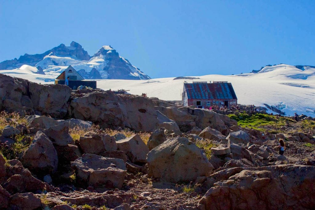
Cerro Tronador Hike (Bariloche, Argentina)
Starting Point: Pampa Linda, near Bariloche
Highest Point: Refugio Otto Meiling 2000m (6500ft)
Total Length: 27km ( 16 miles )
Difficulty: Hard
Duration: 3 days
Trek Type: Out-and-Back
Tour Type: A professional guide is mandatory
The hike from Pampa Linda to Puerto Blest takes three days with a night spent at Refugio Otto Meiling at the base of Cerro Tronador in the Nahuel Huapi National Park. The second night is spent at Agostino Rocca Hut. From Pampa Linda, the trail ascends through forests and meadows, providing panoramic views of glacial valleys and turquoise lakes. Above the tree line, the trail is rugged with a glacier traverse being needed to reach the Paso de las Nubes down into the Frías Valley for the second stage of the trek. The hike ends with a cruise from Puerto Blest back to Bariloche.
Cerro Tronador has three distinct peaks and dominates the scenery from the start at Pampa Linda. The name means ‘Thunder Mountain’ and the avalanches on the glaciers can be heard echoing across the valley as you hike. The trail is well marked but unless you return to Pampa Linda on the same trail you will need a guide to cross the glacier. These can be found in Bariloche and will organise the trek including the accommodation and the transfers to Pampa Linda.
Recommended by Suzanne from Meandering Wild
Salkantay Trek (Peru)
Starting Point: Soraypampa
Highest Point: 4,629 m (15,190 ft)
Total Length: 74 km (46 miles)
Difficulty: Hard
Duration: 5 days (4 nights)
Trek Type: One-way (Point-to-Point)
Tour Type: Self-guided but an experienced guide is recommended
The Salkantay Trek is one of the most scenic hikes in South America, located in the Andes Mountains of Peru, starting in the town of Soraypampa. The trek is one of the most popular tours in Cusco, one of the safest cities in Peru.
Salkantay Trek is an alternative more challenging trek to the famous Inca Trail. Compared to the Inca Trail, where a costly permit is required, the Salkantay Trek can be a better option if you are fit and traveling on a budget. Both treks usually end at Machu Picchu, the Lost City of Incas, and one of the Seven Wonders of the World.
Named after Mount Salkantay, the highest peak along the trail, this trek offers a diverse range of landscapes, including high mountain passes, cloud forests, and lush valleys. Salkantay Pass is the highest point of the trail, which stands at 4,629 meters. The trek usually takes around 4-5 days, depending on the specific route and the pace of the trekking group. Since it’s a challenging hike with a lot of elevation gain, it’s best suited for experienced travelers who can handle physical challenges.

Recommended by Daria from The Discovery Nut
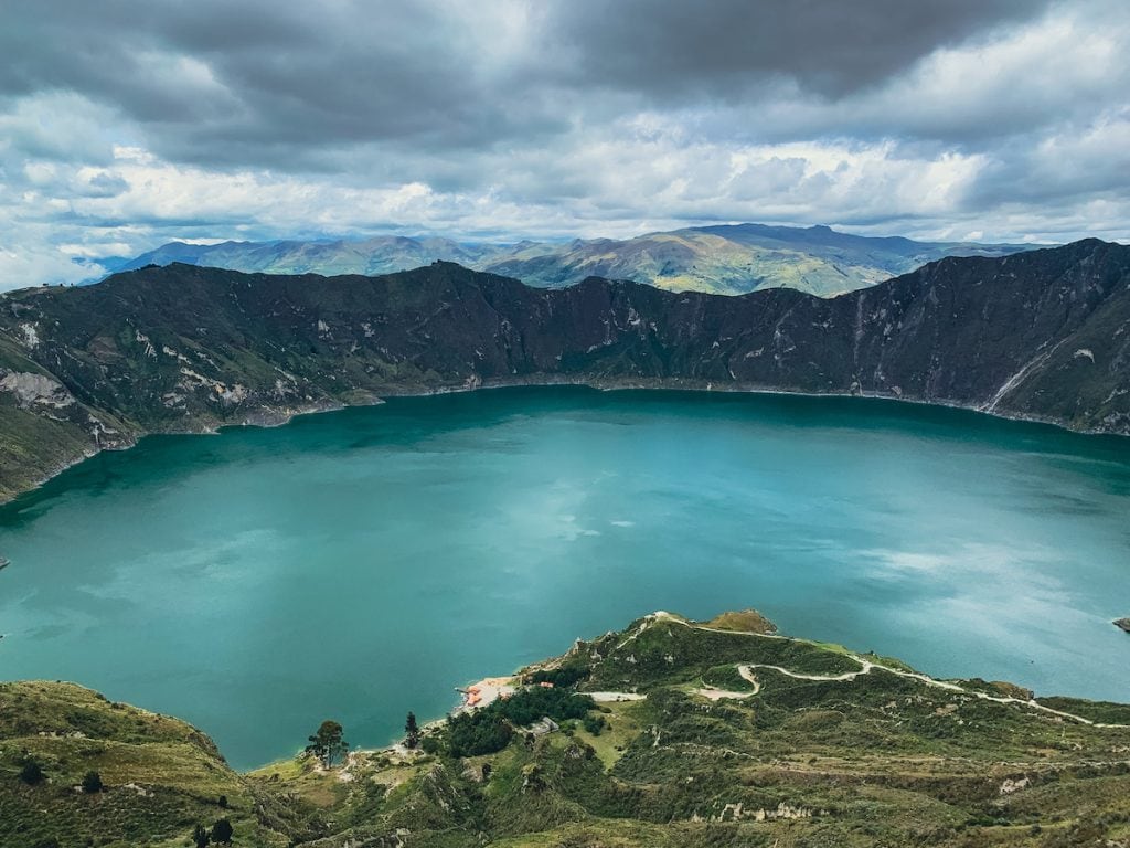
Quilotoa Loop Trek (Ecuador)
Starting Point: Latacunga
Highest Point – 3,859 m (12,660 feet)
Total Length – 38.5 km (24 miles)
Difficulty – Moderate
Duration – 3 days
Track Type – One Way (Point to Point)
Tour Type: Self-guided
GPS Track – 3 Day Quilotoa Loop Map
One of the best multi-day treks in South America is the Quilotoa Loop Trek in Ecuador. This stunning trek passes through tiny hamlets and is immersed in the beauty of the Ecuadorian Highlands.
The point-to-point trek can either end or begin from the crater lake of Quilotoa. Most hikers choose to trek from Sigchos to end with the views of the Quilotoa Lake.
Almost everyone will head to Latacunga and sleep there to catch a local morning bus to Sigchos. There is an international airport in Latacunga (Cotopaxi International Airport), but budget travelers typically take the bus from Quito to Lataunga. As this is a top destination in Ecuador, there are numerous day trips from Quito.
The Quilotoa Loop trek can be completed independently or with a guide. Guides can be hired before departing on the trek or in the local villages. The hike is moderate, but it’s the altitude that adds an extra challenge.
Hikers stay at local guesthouses in mountain pueblos along the route. The guesthouses include dinner and breakfast and offer a small packed lunch for the following day for an additional fee.
The Quilotoa Loop trek is one of Ecuador’s most beloved treks for its diverse landscapes, natural beauty, and the chance to stay in small mountain communities.
Recommended by Megan from Packing Up The Pieces
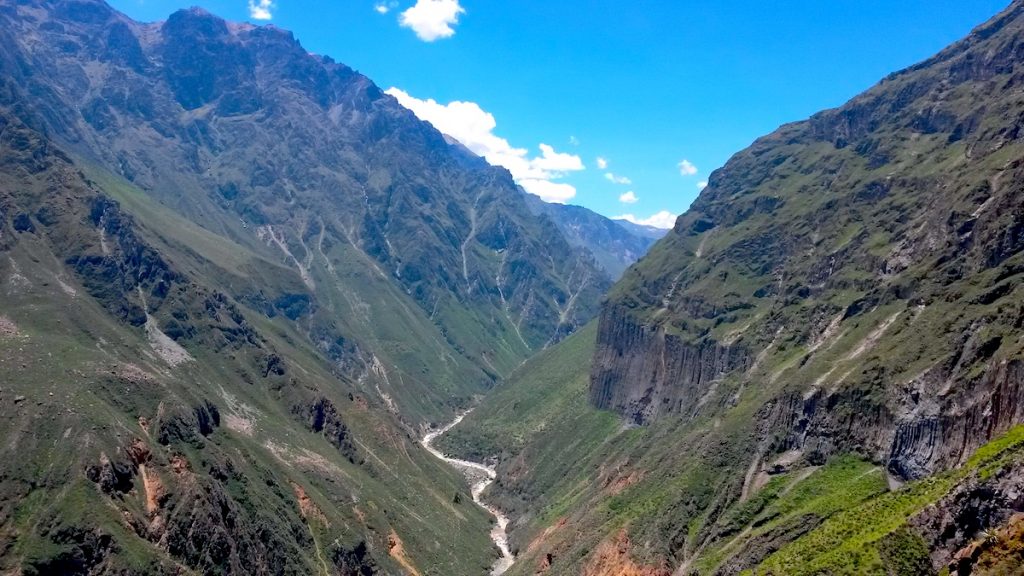
Colca Canyon (Peru)
Starting Point of the Hike: Cabanaconde
Highest Point: 3287 meters (10784 feet)
Total Length: 27 km (16.7 miles)
Difficulty: Moderate
Duration: 2 days
Track Type: Roundtrip
Tour Type: Self-guided but a professional tour guide is highly recommended due to the altitude.
Hiking the Colca Canyon should be on anyone’s hiking bucket list. This 2-day trek takes you to the deep of the second-deepest canyon in the world at 3270 meters of depth in an incredibly beautiful landscape. The highlight of this hike, however, is (surprisingly) not the nature, but the majestic Andean Condor flying over the canyon. The Andean Condor has a wingspan of over 3 meters making it one of the largest birds in the world.
To get to the trailhead, you must take the bus from Arequipa, there are plenty of guided tour options too, and it will drop you off at the right spot along the road. From dry and rocky on the top of the canyon, you’ll reach a lush, green bottom of the canyon where exotic fruit trees grow in abundance. A guided trek will typically take you to a small settlement at the bottom of the canyon where you get served a delightful lunch made of fresh, local produce before you continue to an oasis to spend the night. There you will have time to swim in the pool before dinner. Day two starts early before sunrise and takes you steeply to the top of the canyon in only 3 hours – which is strenuous!
Recommended by Linn from Brainy Backpackers
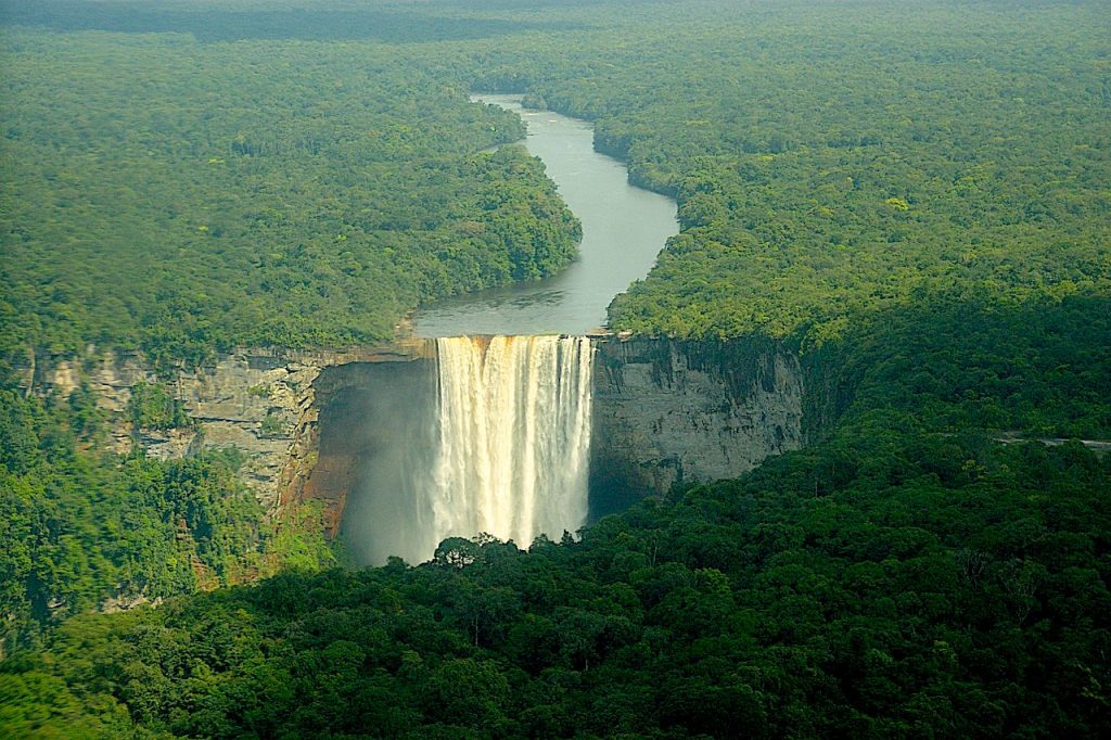
Kaieteur Falls Trek (Guyana)
Starting Point: Georgetown
Highest Point: 2,000 feet (609 meters)
Difficulty: Easy / Moderate
Duration: 3 hours (by plane) to 5 days (overland trek)
Trek Type: Out and Back
Tour Type: Self-guided but registration with local park rangers is required.
Kaieteur Falls is the world’s largest single-drop waterfall by volume. Water plummets down a sheer drop of 741 feet (226 m) over the edge of a sandstone plateau. Kaieteur Falls is one of the most incredible natural wonders of South America and one of its best-kept secrets.
There are two options to get to the falls:
Option 1: take a flight to and then walk for 2-3 hours until you get to the falls
Option 2: a 5-day overland journey which includes a river cruise, staying overnight in jungle camps, hiking 2 days through the Amazon rainforest, and a panoramic flight back to Georgetown.
Kaieteru Falls are some of the best off-the-beaten-path treks in South America not yet discovered by mass tourism.
Best Time to Go Hiking in South America
The best time to go hiking in South America depends on the specific region you plan to visit, as the continent encompasses a wide range of climates and ecosystems. Here are some general guidelines for different regions.
Andes Mountains (Peru, Ecuador, Colombia, Bolivia):
The dry season (May to September) is generally considered the best time for hiking in the Andes. During these months, you’ll encounter more stable weather conditions with less rainfall and clearer skies. Keep in mind that popular treks like the Inca Trail in Peru may have limited availability, so it’s advisable to book in advance.
Patagonia (Argentina and Chile):
The best time to visit Patagonia for hiking is during the Southern Hemisphere’s summer, which is from late October to April. The weather is milder during these months, and many trails are accessible. However, be prepared for variable weather even in the summer, as Patagonia is known for its unpredictable conditions.
Colombian Sierra Nevada and Caribbean Coast:
The dry season from December to March is a good time for hiking in the Sierra Nevada and along the Caribbean Coast of Colombia. During this period, you’ll encounter less rainfall and more favorable hiking conditions.
Is it Safe to Hike in South America?
Hiking in South America can be a wonderful and rewarding experience, but like any outdoor activity, it’s important to be aware of potential risks and take necessary precautions.
Hire a Professional Guide:
For most hikes in South America, a professional tour guide is highly recommended because the trails are usually not well marked and it is easy to get lost. Plus it’s always safer to hike in a group rather than solo.
Check Travel Advisories:
Stay informed about travel advisories and warnings for the countries you plan to visit. Government websites and travel forums can provide valuable information.
Weather Awareness:
South America has diverse climates, so be prepared for varying weather conditions. Check the weather forecast before starting your hike.
Travel Insurance:
Consider purchasing travel insurance that covers emergency medical expenses, evacuation, and other potential issues.
Hiking Gear:
Ensure you have appropriate hiking gear, including sturdy footwear, weather-appropriate clothing, navigation tools, and a first aid kit.
It’s important to exercise caution and use common sense when exploring unfamiliar areas in South America. Always stay informed, plan ahead, and be prepared for unexpected situations.
Disclosure: This article may contain affiliate links. If you purchase something through them, I may earn a small commission at no cost to you. It’s a win-win for both of us and helps to keep this content free.
Great post 👏